


69620_stlo-160423-comité_fêtes

adye
User

Length
14.6 km

Max alt
433 m

Uphill gradient
375 m
Km-Effort
19.5 km

Min alt
283 m

Downhill gradient
369 m
Boucle
Yes
Creation date :
2016-04-24 00:00:00.0
Updated on :
2016-04-24 00:00:00.0
3h29
Difficulty : Difficult

FREE GPS app for hiking
 SityTrail
IGN / Geographical institutes
SityTrail Plus
The world is yours!
About
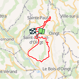
Trail Walking of 14.6 km to be discovered at Auvergne-Rhône-Alpes, Rhône, Val d'Oingt. This trail is proposed by adye.
Description
Randonnée du Comité des fêtes sur Saint-Laurent-d'Oingt en 2 parties:
- Bourg, Paradis, Vacheron, Roche, Granges
- Mont Joli, Vervuis, Mussy, Bourg.
Positioning
Country:
France
Region :
Auvergne-Rhône-Alpes
Department/Province :
Rhône
Municipality :
Val d'Oingt
Location:
Saint-Laurent-d'Oingt
Start:(Dec)
Start:(UTM)
621218 ; 5089120 (31T) N.
Comments